Hurricane Matthew’s projected path has shifted slightly, bringing it closer to Florida’s east coast later this week, but forecasters say their predictions are still fairly uncertain.
And even if Matthew gets close to the coast, it’s too early to say what exactly Florida will see.
“Right now it looks like the worst of it is going to be over the Atlantic,” said Matt Volkmer, meteorologist with the National Weather Service in Melbourne. “We’re just going to have to watch to see how close the track comes.”
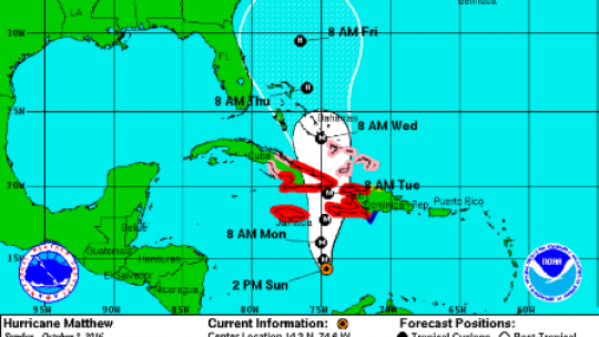
Matthew has been creeping north toward Jamaica and Haiti today as a powerful Category 4 storm, bringing 140 mph winds and possibly life-threatening rain to the island countries.
Hurricane warnings have been issued for both Jamaica and Haiti, along with parts of Cuba and the southeastern Bahamas, according to the National Hurricane Center in Miami.
Rain had already started lashing parts of Jamaica, which could see as much as 15 inches of rain during the next few days. Forecasters say it’s Haiti, though, that will most likely see the worst of the storm.
Matthew is expected to reach southern Haiti by tonight and could produce up to 40 inches of rain in some spots, raising concerns about life-threatening flooding and mudslides, according to the Hurricane Center.
Cuba also is expected to see possibly-dangerous amounts rain when Matthew crosses the lightly populated southeastern tip of that country on Tuesday. The storm should then be in the Bahamas by Wednesday and heading up Florida’s east coast on Thursday.
Latest predictions show Matthew moving almost parallel to the coast and staying offshore. Volkmer said local impacts will vary depending on how close Matthew gets to the state.
Strong rip currents, high storm surge and large swells are probable, he said. There’s also a chance the coast could see tropical storm force winds.
“For right now, there’s still a great deal of uncertainty but the probability to see tropical storm force winds have been increasing a little bit,” Volkmer said.
Volusia County officials have already started preparing for possible impacts by moving unsecured signs and lifeguard towers, so they won’t get swept away or damaged.
Gov. Rick Scott has urged Floridians to get ready, just in case Matthew turns toward the state.
“This storm is catastrophic, and if it hits our state, we could see impacts that we have not seen in many years,” he said in a statement released Sunday. “Even though the storm’s projected path is just east of our state, no one should take this lightly.”
As of 11 a.m., Matthew was 275 miles southwest of Port Au Prince, Haiti and moving north at 6 mph, according to the Hurricane Center. The storm’s winds decreased overnight to 130 mph from a high on Friday of 160 mph. The winds speeds have changed a little this morning, but Matthew has remained a Category 4 storm since Saturday.
Even still, the Hurricane Center warns that such a powerful storm can cause “severe damage” to homes and other structures, while toppling trees and power poles. “Catastrophic damage will occur” with a Category 4 storm, the Hurricane Center says.
Officials with Haiti’s civil protection agency said there were roughly 1,300 emergency shelters across the country, enough to hold up to 340,000 people. Authorities broadcast warnings over the radio telling people to swiftly heed evacuation warnings, trying to counter a common tendency for people to try to stay in their homes to protect them during natural disasters.
Teams of civil protection officials walked the streets of Les Cayes and other areas urging residents to secure their homes, prepare emergency kits and warn their neighbors. They also evacuated people from some outlying islands.
After passing Jamaica and Haiti, Matthew was projected to reach Cuba. The center was expected to pass about 50 miles east of the U.S. Navy base at Guantanamo Bay, where authorities evacuated about 700 spouses and children of service members on military transport planes to Florida.
Matthew is expected to weaken back to a Category 2 storm by Friday, according to the Hurricane Center. If it stays on its current projected path, it will then head toward the Carolinas this weekend.
The Associated Press contributed to this report.
SOURCE: OrlandoSentinel