Hurricane Matthew became the fifth hurricane of the 2016 Atlantic hurricane season early Thursday afternoon.
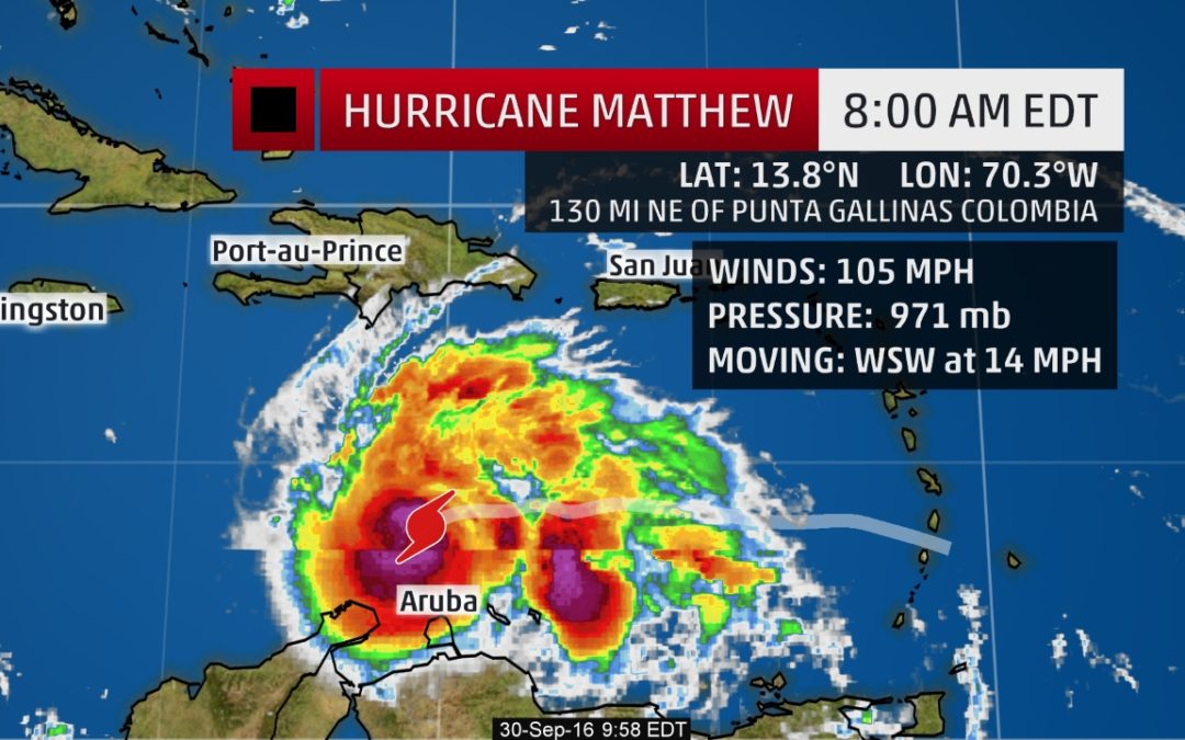
Matthew was located 130 miles northeast of Punta Gallinas, Colombia, as of Friday morning.
Current Storm Status
A Hurricane Hunters reconnaissance mission early Friday morning measured flight-level winds a few thousand feet above the sea of just over 114 mph north of the eye, prompting the upgrade to Category 2 status.
Matthew will continue to strengthen and should become a major hurricane (Category 3) later in the day.
A tropical storm watch continues for Aruba, and the northern coast of Colombia. The hurricane watch for Curaçao has been discontinued. Winds of 40 mph or greater are possible in Aruba this morning, and in northern Colombia on Friday afternoon.
Current Watches/Warnings
Radar from Curaçao overnight indicated that a sturdy eyewall was apparent and that lightning was probably taking place in the northern eyewall. Lightning is often a precursor or icon of phases of strong intensification.
The ‘Caribbean Right Turn’
Matthew is currently experiencing some wind shear provided by southwest winds several thousand feet above the surface, which has blown convection away from its center of circulation. Matthew has proven that wind shear can be supportive of strenthening in some conditions.
Strengthening is forecast throughout at least the next two days, or through Saturday evening. Matthew is forecast to become aCategory 3 hurricane by this evening, however, if the current rapid intensification phase continues that upgrade could come earlier.
First up, given the southern track, outer bands of rain and winds to tropical storm force are possible in portions of the typically drier “ABC Islands” – Aruba and Curaçao – as well as parts of coastal Venezuela and Colombia Thursday through early Saturday.
Beyond that, uncertainty is still considerable on the critical details of this system.
(MORE: Just Because It’s Fall Doesn’t Mean We Shouldn’t Pay Attention to the Tropics)
Over the next couple of days, Matthew should continue to move west or just south of due west as it rides the southern periphery of the Bermuda high.
Sometime on Saturday or early Sunday, Matthew should make its long-anticipated northwest or northward turn in the Caribbean Sea, as the system reaches the southwestern edge of the Bermuda high.
The critical details regarding when exactly that turn is made, how sharp it is, and Matthew’s intensity at that time will dictate the impacts for Jamaica, Hispañola, and eastern or central Cuba.
Unfortunately, there is still some important forecast uncertainty regarding those important details, which is common for a tropical cyclone forecast several days out. Phases of rapid intensification like the one experienced by Matthew on Thursday and Friday only hamper efforts to gain a better handle on the forecast.
(MORE: Facts/Myths About the Hurricane Cones of Uncertainty)
For now, impacts could begin in Jamaica and Hispañola (particularly Haiti) as soon as Sunday night, and in eastern Cuba as soon as Monday.
In addition, there is uncertainty regarding Matthew’s intensity as it nears those locations. Matthew may be stronger than the current forecast.
Source: WEATHER CHANNEL